JULIETTE, GA
| RIDE TYPE Gravel | DISTANCE Varies | ASCENT Varies |
| PAVEMENT 15% | COURSE Loops | TERRAIN Rolling |
| GRAVEL 85% | SETTING Forest | HIGHEST POINT 644 Feet |
The Fried Green 27/42/50 routes explore the extensive network of gravel roads in and around the Piedmont National Wildlife Refuge near Juliette, Ga. Located little more than an hour south of Atlanta, three lengths provide options for riders of all abilities. All feature pristine pine glades and hardwood forests, rolling and sometimes playful terrain, a few creek crossings and postcard perfect gravel.
The Fried Green 50 gravel route has become a classic and several shorter versions are posted on the internet under various names. All share a common denominator – the Piedmont National Wildlife Refuge. That the area gets so much attention is a testament to its idyllic setting and high quality gravel. The three route options are:
| Fried Green 27 27.0 mi/1697 ft | Fried Green 42 41.9 mi/2564 ft | Fried Green 50 52.0 mi/3013 ft |
The Piedmont NWR is administered by the US Fish & Wildlife Service as part of the National Wildlife Refuge System. Unlike public lands which are often managed to support competing interests, the refuge system exists for for a singular purpose – conservation. Everything about the Piedmont NWR, including what’s permitted for recreation, serves that purpose. Riding here is a privilege.
Piedmont NWR was established in 1939 as a “combination wildlife and game-management demonstration area” to demonstrate that wildlife could be restored on worn out, eroded lands. Ira Gabrielson, Chief of the Bureau of Biological Survey, predecessor agency of the US Fish & Wildlife Service, selected Piedmont from a list of Resettlement Projects. He stated that if the Bureau could take a piece of completely worn out and useless land, like Piedmont was at the time, and make it into a productive wildlife area, then he would know that any kind of land could be managed for wildlife.
https://www.fws.gov/refuge/Piedmont/about.html
The universally accepted start location is the boat ramp/park near the rough assortment of buildings known as Juliette, GA. You may spot a bald eagle soaring above the Ocmulgee River after sunrise and probably won’t be the only cyclist getting ready on a nice weekend. Take a moment to soft pedal through town and check out the old mill. The movie Fried Green Tomatoes was filmed in Juliette.


All three options use pavement only when absolutely necessary. The 42 and 52 mile versions extend further east for a bottle refill in the hamlet of Round Oak where an adventurous and fit cyclist could pick up the Red Clay Ramble route. The two longer options will necessarily spend more time on county maintained gravel and include a few extra miles of pavement.
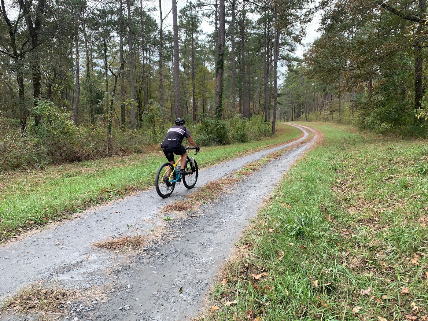
Gravel maintained by Uncle Sam within the refuge is superb, ranging from glassy smooth boulevards to gorgeous doubletrack. The place defines the phrase “Well groomed” and the photos below show typical conditions. Terrain is gently rolling with a few kickers here and there. Several creek crossings keep things fun as they seem to pop up out of nowhere rounding a curve or on a short descent. Heavy rains might necessitate crossing on foot for the sake of your bottom bracket.


The road system within the refuge is a labyrinth so bring and trust your GPS. Some roads look great on the map but are actually closed to all but foot traffic. Signs make the rules very clear. SoutheastCyclingRoutes.com always respects land use rules and the Fried Green routes are no exception. Check the Must Know and Logistics tabs for links to important information such as hunting closure dates and facilities hours so that there are no surprises.
The only possible services on the Fried Green 42/52 routes is a water spigot located at the Georgia Forestry Commission fire tower on Monticello Highway. The location is indicated on the map but you really can’t miss the fire tower. The Fried Green 27 route has no refill point and all three routes are without store stops so expect to be self-sufficient.
Your input helps others learn about great cycling routes so please consider sharing your experience in the comments section below.
| Special thanks to SoutheastCyclingRoutes.com contributor GREG HANCHAR for assistance scouting the Fried Green 27/42/50 routes. |


- Vehicles (including bicycles) are prohibited from a significant portion of the roads in the National Wildlife Refuge. The Fried Green 27/42/50 routes respect the rules and utilizes only roads where cycling is permitted.
- The refuge is closed to everyone except permitted hunters during firearm deer hunts in the fall. Check the Piedmont National Wildlife Refuge Hunting and Fishing regulations page for specific dates.
- Little Rock Wildlife Drive is typically closed from Nov 15 through Feb 15 and will not be accessible between these dates. The road is located at Mile 11.5 on the 42 mile route and mile 14.9 on the 52 mile route. Continue east on Round Oak Julette Rd instead.
- Some websites incorrectly state that a Georgia Land Pass or hunting/fishing license is required. The NWR permits page however states, "A Georgia WMA license is not required since the refuge is NOT a state area." The Fried Green 27/42/50 routes do not pass through any Georgia Wildlife Management Area and so a Georgia Land Pass or hunting/fishing license is not required to ride the Fried Green routes.
- Free parking is available at the start location. There are a few picnic tables and a garbage can but no restrooms or water.
- Water is available at the Georgia Forestry Commission office/fire tower located at mile 27.5 on the 52 mile route and mile 24.2 on the 42 mile route. When asked whether the spigot was left on during the winter, a member of the Ocmulgee Mountain Bike Association replied, "It’s always been on year round." The spigot is at the corner of the main building. There is a second spigot behind the rear buildings.
- Water is not available on the 27 mile route apart from filtering.
- The only other possibility for water is the NWR visitor center which is only open Monday to Friday.
- All three routes lack store stops so bring whatever food you need.
- Convenience stores are located about 1 mile west of the start location at the corner of Julette Rd and US 23 (GA Hwy 27).
- The nearest full service town is Forsyth, located about 10 miles west of the start location along the I-75 corridor.
Terms of Use: Use of this route is at your own risk. This route map and associated route descriptions are believed correct at the time of publication but accuracy cannot be guaranteed. You assume all responsibility for 1) checking weather and road conditions, 2) knowing and obeying land use rules and restrictions, 3) knowing and obeying all rules of the road, 4) carrying and using proper safety and navigation equipment and, 5) knowing the limits of your physical ability. SoutheasCyclingRoutes.com, contributors and Timothy Hollingworth are in no way liable for personal injury, damage to personal property, or any other loss to individuals following this route or using information contained in the route map or description.
We did the FG42. Great ride. Beautiful property. Spent some time watching a bald eagle circle over a lake. All in all, a splendid experience. Plenty of work to do on this ride. The final rides down to the creeks are fast and bumpy, and the hills on the other side are plenty steep. But even if you have to walk the tough bits, as my wife did, it’s still well worth the time and effort.
Rode the 50 mile route yesterday (3/6/2023). Lots of prescribed burns going on throughout the NWR which meant lots of closed gates. I even stumbled upon one of the fire crews on an open road who were working a burn. I was told I could continue on but that it would be smokey. As for the route, in terms of quality and character, very similar to the 42 which I did a couple of months ago. My favorite sections were 3-loop road (miles 3-8), Pasture Field rd. (miles 12-14) and the whole Little Rock Wildlife loop. I found the gravel to be smoothest in these sections, the descents booming fast and flowey, and the climbs a lot of fun as well. The latter half of this route (miles 30 on) had lots of fresh loose gravel that made climbing tough and the descents kinds scary since you never knew when you were going to hit a thick sand-pit-like batch of gravel. It keeps you on your toes. Stream crossings were plentiful on the 50 miler (5ish I believe) and the water was a little high making them extra tedious but you can always get off and walk.
Did this route yesterday. Roads were in good condition. Be prepared to modify route if certain roads are closed. I encountered 2 closed gates with “no cycling” signs. I had already passed the Wildlife Officer once so I decided not to chance it. After turning back, I noticed the officer hiding behind some trees. I spent the next 20 min pondering whether the road was actually closed or he was just setting a trap to catch me breaking some rules to give me a ticket. Never seen so many no trespassing and do not enter signs. Still would recommend route. See my RWGPS below. https://ridewithgps.com/trips/86825017
Rode the 27 miler solo yesterday. Passed by 3 pick-up trucks and no other riders all day. All in all it was a great peaceful ride. The solitude was welcomed. The road surfaces were good overall, some big gravel here and there, but mostly good hard packed cruising stuff. Two of the creek crossings were easy to peddle through, the last two, got my feet wet (cold feet for a January ride). Thanks for the intel. On to Murder Creek for the next ride.
We did the fried green 27 (closer to 28) last week. Map was accurate – thanks. The scenery was beautiful and the creek crossings a lot of fun. But man was that a tough slog: the gravel was chunky and loose, our speed was slow, and we were beat by the end. Not sure if new rocks were laid down or what, but that was way tougher than expected. Definitely recommend because it’s so scenic and serene, but be prepared that it’s no easy cruise. Thanks for the great routes! Keep em coming.
I rode the Fried Green 28 today and thoroughly enjoyed it — great route and a good mix of smooth and some chunkier gravel, but generally all in very good shape. I’m relatively new to gravel riding and this was an accessible route but still provided plenty of challenge and some good skills development opportunities, especially the creek crossings (I made 2, hiked one). Very quiet out there – saw maybe 3 cars and zero cyclists on a late afternoon/ early Friday.
One note – the Givens Field road was blocked off on both ends with signs saying no bikes allowed. It was an easy detour — I just continued west on Pond 7A Road and then south on Star Road until it turned into Barron-Russell.
Thanks for the great route and intel!
I’m glad you enjoyed the route Amanda. I apologize for the mistake and thank you so much for the correction. The map and route description have been updated.
-Tim-
The Fried Green 50 was great today, February 21. We got to 63 degrees. Good thing too because the five creek crossings did not look like the the photos here. I guess it has rained a lot. After hiking the second crossing I did ride across it twice. But the creek levels were much higher and the current was strong. In the photos the creeks look pond like. The creeks just added a little sense of adventure to a great ride, that came in at 4,000 feet of elevation change on my Garmin, my companion’s Wahoo. Strava with elevation corrections showed 3,800.
John, thanks for the FANTASTIC feedback! This is so valuable to other riders who can get a better sense of the routes. I’m glad you are enjoying the routes!
-Tim-