
ESOM HILL, GEORGIA
| RIDE TYPE Mixed-Surface | DISTANCE 46.9 Miles | ASCENT 3559 Feet |
| PAVEMENT 38% | COURSE Figure Eight | TERRAIN Hills, Rolling |
| UNPAVED 62% | SETTING Forest, Rural | HIGHEST POINT 1395 Feet |
The Esom Hill Adventure route pushes the boundaries of what’s possible on a gravel bike. There’s almost 18 miles of genteel country pavement but much of the remaining 29 miles consists of jeep roads, frog puddles and a few sections of straight up bedrock. Throw in a crossing of Terrapin Creek and a little bit of hike-a-bike and you have yourself a bonafide adventure ride! This 47 mile mixed-surface route starts just a stone’s throw from Alabama at the Silver Comet Trailhead in Esom Hill, Georgia.
Perspective is everything. Hardcore roadies will wonder why anyone would subject themselves to such a thing. Mountain bikers simply call this an enduro. Ridden on a drop bar gravel bike, the Esom Hill Adventure route is sure to evoke both superlatives and cursing. Its relatively tough compared to other routes but also super interesting and very pretty. Road surface and terrain change constantly. There’s a lot to keep riders occupied.
The route starts one mile east of the Alabama/Georgia line, at the Esom Hill trailhead on the Silver Comet Trail. The trailhead’s deluxe amenities include cell service and lots of shade. It’s a bring-your-own-everything kind of place with room for fifteen or so cars.
Leaving the trailhead, the first few miles consists of concrete rail trail, quiet country asphalt and well groomed gravel with some wonderful views of pastures and lakes. Riders get their first taste of fun as the route climbs Fire Mountain Rd on metamorphic bedrock. Rolling terrain follows as the route heads west over Treat Mountain toward Alabama. You’ll pass through some impressive Kudzu forests before reaching an area of labyrinthine roads heavily abused by logging trucks around mile 10. It’s easy to get turned around here so bring your GPS and trust it.


The party gets into full swing as the route heads west and crosses the state line. Cleburne County Rd 202 is a jeep road, which is to say gnarly by gravel bike standards, and it gets more so over its length. Just when you have had enough, the road levels off and pops out onto chipseal at mile 17. Those who have bitten off more than they can chew can bail out north 2.5 miles to the Silver Comet Trail. The rest will turn south.
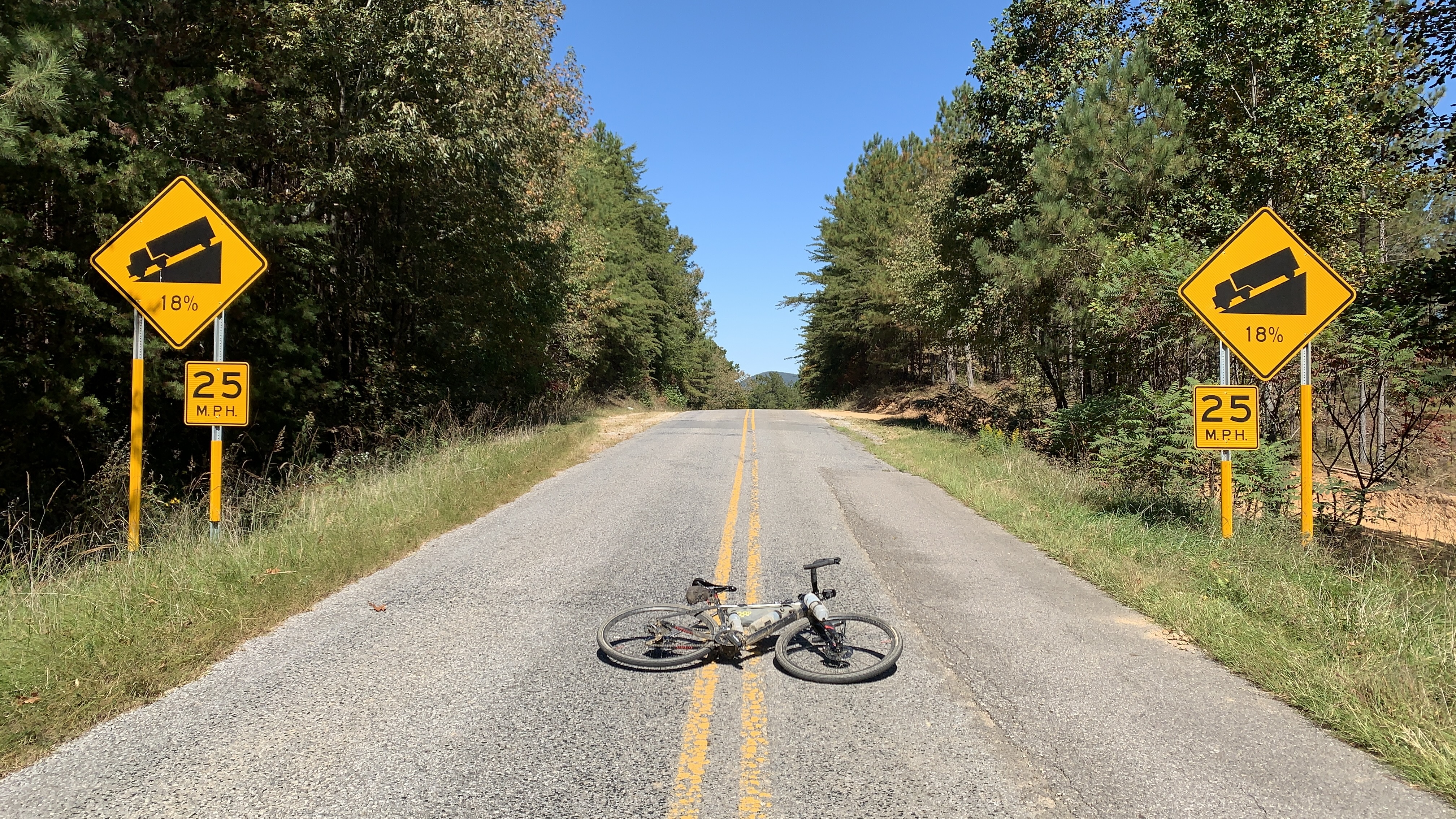
Pavement, such as it is, offers some respite but a short climb will keep everyone humble. Maps put the grade at 13%. Signs at the top say 18%. Either way, be sure to take a trophy photo at the top.
Pilgrims Rest Rd is pretty, passing some beautiful ranches in the first miles and traveling through hardwood forest in the later sections. Areas cut by loggers may offer views of the surrounding hills. Terrain might look familiar to those who have ridden the Shake N’ Brake and Duggar Mountain routes; both are less than four miles away via a right turn at mile 25.7. The 7.5 mile gravel segment is sometimes chunky and a bit of a grind but a long paved sector with a store stop will allow you to collect yourself after. Those running short on water prior to reaching pavement can take advantage of the spigot at Pilgrim’s Rest Church. The location is marked on the maps below.
A few miles of pavement follows the store stop before the route reenters the woods on logging roads and drops down to ford Terrapin Creek. For the sake of clarity, the cover photo above was taken on a blisteringly hot day and riders were dipping into the deeper part of the creek to cool off. Stay to your left and it’s likely to be only ankle deep. SoutheastCyclingRoutes.com has ridden the Esom Hill Adventure route three times and each time the hike-a-bike up the hill on the far side of the creek was more difficult than the crossing itself. An alternate route which bypasses the creek crossing is provided below, just in case. Use your judgement and go around if there’s any doubt.


Once across the creek, tires won’t touch pavement until the last two miles of the route. There’s more logging roads which can be muddy if the weather has been wet. Pay particular attention to your GPS at mile 42 where the route makes an acute left hand turn. A 2.5 mile descent over extremely fast hardpack rewards riders before reaching pavement for the final run in to Esom Hill.
The Logistics and Must Know tabs below contain important information to check before heading out. Some of the roads on the Esom Hill Adventure route don’t see many cyclists so be sure to let everyone know about your experience in the comments section below.


- Pilgrim's Rest Church has a spigot to the right of the front door. The church is located on Pilgrim's Rest Rd at mile 26.4.
- Mountain Creek Church has a restroom with running water to the rear of the building. The door may or may not be locked. The Church is located at mile 39.8 on the regular route. The route which bypasses the creek crossing does not pass the Church.
- There may be a few dogs on the first few miles of pavement after the store stop. These came out to bark but were easily stopped with a commanding voice. SoutheastCyclingRoutes recommends carrying pepper spray just in case.
- Bale out right at the end of gravel at mile 17.2. The Silver Comet Trail is only 2.5 miles away.
- Parking is free at the Esom Hill trailhead.
- There are no toilets or running water at the trailhead.
- The nearest towns with services are Cedartown, Georgia located approximately 10 miles east of the route start and Piedmont, Alabama approximately 15 miles to the west. Both will have restaurants, shops, medical care, etc.
Terms of Use: Use of this route is at your own risk. This route map and associated route descriptions are believed correct at the time of publication but accuracy cannot be guaranteed. You assume all responsibility for 1) checking weather and road conditions, 2) knowing and obeying land use rules and restrictions, 3) knowing and obeying all rules of the road, 4) carrying and using proper safety and navigation equipment and, 5) knowing the limits of your physical ability. SoutheasCyclingRoutes.com, contributors and Timothy Hollingworth are in no way liable for personal injury, damage to personal property, or any other loss to individuals following this route or using information contained in the route map or description.
Hey there. Any camping along the way? Thanks for this route. I’m excited. I love Terrapin Creek so much.
Challenging route, I would not recommend on a rigid bike due to very rough terrain on some of the forest service roads. Also very few stops for water so plan accordingly