PIEDMONT, AL
| RIDE TYPE Mixed Surface | DISTANCE 99.9 Miles | ASCENT 11,040 Feet |
| COURSE Out and Back | TERRAIN Mountains | SETTING Forest |
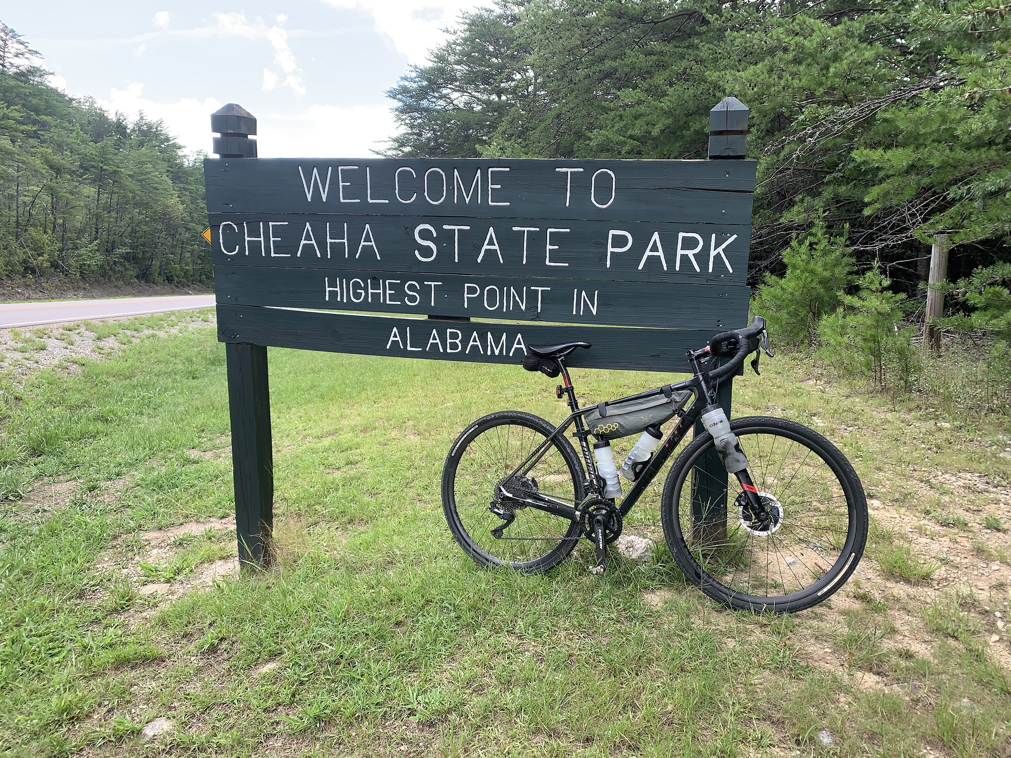
The 100 mile Alabama Skyway route starts along the Chief Ladiga rail trail in the city of Piedmont, Alabama. 40% of the route is on gravel roads through the Talladega National Forest and along the edge of the Duggar Mountain Wilderness. Much of the route follows the Skyway Motorway which runs the crest of the Talladega Mountains and includes a paved climb to the highest point in Alabama at Cheaha Mountain State Park. The route is well suited to a two day bikepacking trip if 11,000 feet of climbing is too much for one day.
The Skyway Motorway was to have been Alabama’s answer to the Blue Ridge Parkway. Part of it still exists as unpaved forest service roads and a paved portion is now known as the Talladega Scenic Byway. While it isn’t as well known or as well traveled as the Blue Ridge Parkway, it is extremely beautiful in its own right. The Alabama Skyway route follows the old Skyway Motorway for most of its length.

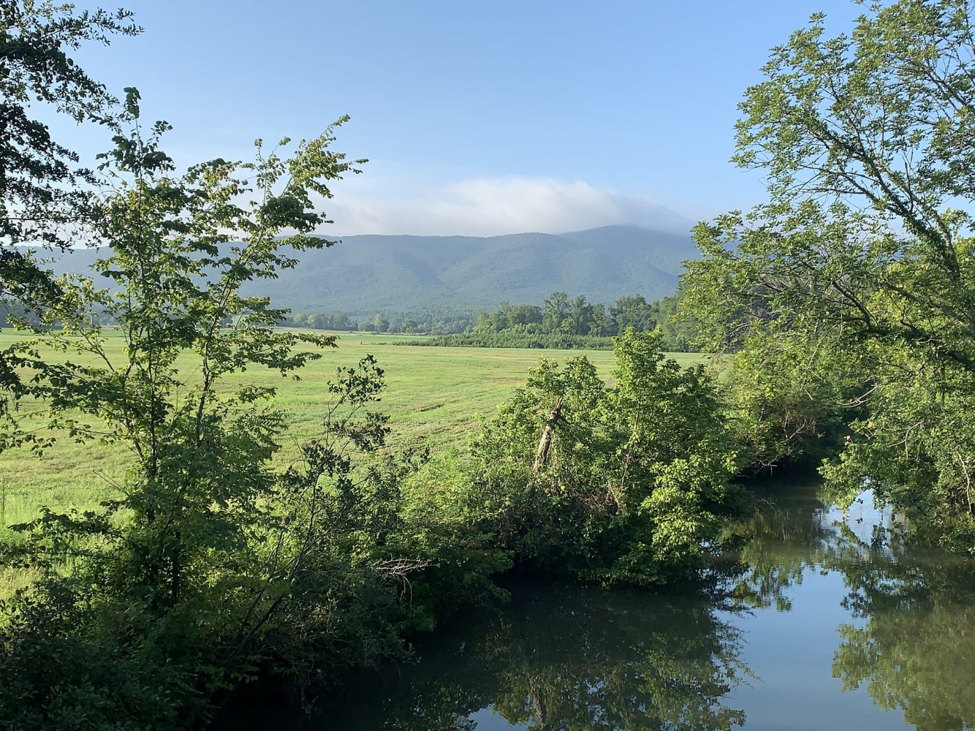
The route starts gently, leaving the city of Piedmont on the Chief Ladiga rail trail with postcard views of Duggar Mountain in the distance. An abrupt turn south signals the impending climb along the eastern edge of the Duggar Mountain Wilderness. The route then undulates, meanders and continues to climb southward through coves and glades in the Talladega National Forest, eventually picking up the paved section of the Skyway and the climb to Alabama’s highest point. Cheaha Mountain is an Alabama State Park with a restaurant, store and other attractions of varying interest to cyclists on an all day adventure. The route is an out-and-back. Turn around when you get to the state park and return the way you came.


The Alabama Skyway route isn’t technical but the sheer number of vertical feet climbed makes it very challenging. The elevation profile looks like a sawblade with Cheaha Mountain prominent in the center. Cheaha is easily the longest sustained climb gaining 1200 feet in just over 3 miles. There are several smaller climbs, especially on the paved skyway and dozens of rollers and kickers in the forest. Very little of this route is flat so be wary of the proverbial “Death by 1000 cuts” and don’t burn your matches early. The final three miles on the rail trail will let you spin out your legs after all that climbing. Hydration may also be a challenge so check the Resupply tab below for important information. Keep in mind that the paved Skyway lacks shade and will be extremely hot in summer.

Also keep in mind that Alabama isn’t the Rocky Mountains and much of the route is forested. There are some impressive views, especially toward Cheaha Mountain but grand vistas are only part of what this route is about. Summer wildflowers which line the gravel roads and the butterflies that come with them, hardwood glades, the sound of a woodpecker, a conversation with a horeseback rider in the forest or a motorcyclist at one of the overlooks – these are are just as likely takeaways. The Talladega National Forest enjoys frequent prescribed burns and the forest has a different character than further north; more open an less claustrophibic. You can read about the how and why of controlled burns here.
As always, check the comments section below for late breaking news and community updates, and don’t forget to add your own update after you ride this route.


- Check the Alabama National Forest Alerts and Notices page for the schedule of prescribed burns before heading out.
- There is a $5 fee to enter Cheaha Mountain State Park but the attendant didn't charge the fee to cyclists on 8/1/2020.
- Water is available seasonally at the Coleman Lake Campground day use area (miles 15 and 85).
- Water is also available seasonally at the Shoal Creek ranger station (miles 29 and 71). The spigot is to the left of the main entrance.
- Store stops are located 1.5 miles west of the ranger station on highway 9 and just east of the paved skyway on highway 431. Both are indicated on the map. The second store stop requires exiting onto Cleburne County Rd 381 at least three miles before the store.
- The Vista Cliffside Restaurant at Cheaha Mountain State Park serves burgers, fries and a breakfast buffet. The restaurant has a cooler in the lobby with bottled water, cokes, etc. Vending machines are located at the hotel across the street from the restaurant.
- Park at the Eubanks Welcome Center along the Chief Ladiga Trail in Piedmont, Alabama.
- Parking at Coleman Lake Campground will shorten the route to approximately 70 miles and 8000 feet.
- Flush and pit toilets are available at the Coleman Lake campground (mile 15 and 85)
- Additional pit toilets are available at Pine Glen campground as indicated on the map.
- Peidmont, Alabama is the nearest town with services and is also the start location. Jacksonville is located approximately 12 miles to the southwest and is the home of Jacksonvile State University.
- Formal campsites are available at Cheaha Mountain State Park, Pine Glen Campground and Coleman Lake Campground. Wild camping is available throughout the national forest and hunting camps are unused during summer.
Terms of Use: Use of this route is at your own risk. This route map and associated route descriptions are believed correct at the time of publication but accuracy cannot be guaranteed. You assume all responsibility for 1) checking weather and road conditions, 2) knowing and obeying land use rules and restrictions, 3) knowing and obeying all rules of the road, 4) carrying and using proper safety and navigation equipment and, 5) knowing the limits of your physical ability. SoutheasCyclingRoutes.com, contributors and Timothy Hollingworth are in no way liable for personal injury, damage to personal property, or any other loss to individuals following this route or using information contained in the route map or description.
I grew up in Anniston and spent most of my youth camping in the forest regularly. I also rode this route with 3 others in 2019. It’s fantastic.
We rode from Atlanta to Piedmont and stayed a night there, and headed to the top of Cheaha in the morning, on day 2, via this same route. We were supposed to ride the section south of Cheaha that Mr. Gregg described in the prior comment, on our 3rd day, but everyone was so worn out, we just took it as a rest day and enjoyed the park. Day 4, we cruised back down to Piedmont, the same way we came in…via the Skyway, and after another night in Piedmont, rode back to Atlanta. The paved Duggar climb is a killer…and if that doesn’t hammer you down enough, the paved climb up Cheaha will.
The gate to Coleman Lake campground is closed but you can still get water there at any of the camp sites. Some of the best parts of the Skyway are south of Mt. Cheaha. The part past Adams gap is gravel and continues all the way to Bulls Gap on Hwy 148. About 25 miles.
Hey Hardwick. I hope your season is going well, such as it is. Thanks for the feedback and for the tips about gravel south of Cheaha. The Skyway route was scouted for the website August 1, 2020 and the gate at Coleman Lake was open. I believe you are correct about water at the campsites although there is water and a shower at the day use area all the way in the back. I wasn’t aware that gravel went as far south as Bulls Gap – looks like another trip to Alabama will have to be planned. Thanks again!